Catalogue PIGMA
Administrative units
Type of resources
Available actions
Topics
Keywords
Contact for the resource
Provided by
Years
Formats
Representation types
Update frequencies
status
Scale
Resolution
-
Proposed regional conservation areas in the Mediterranean
-
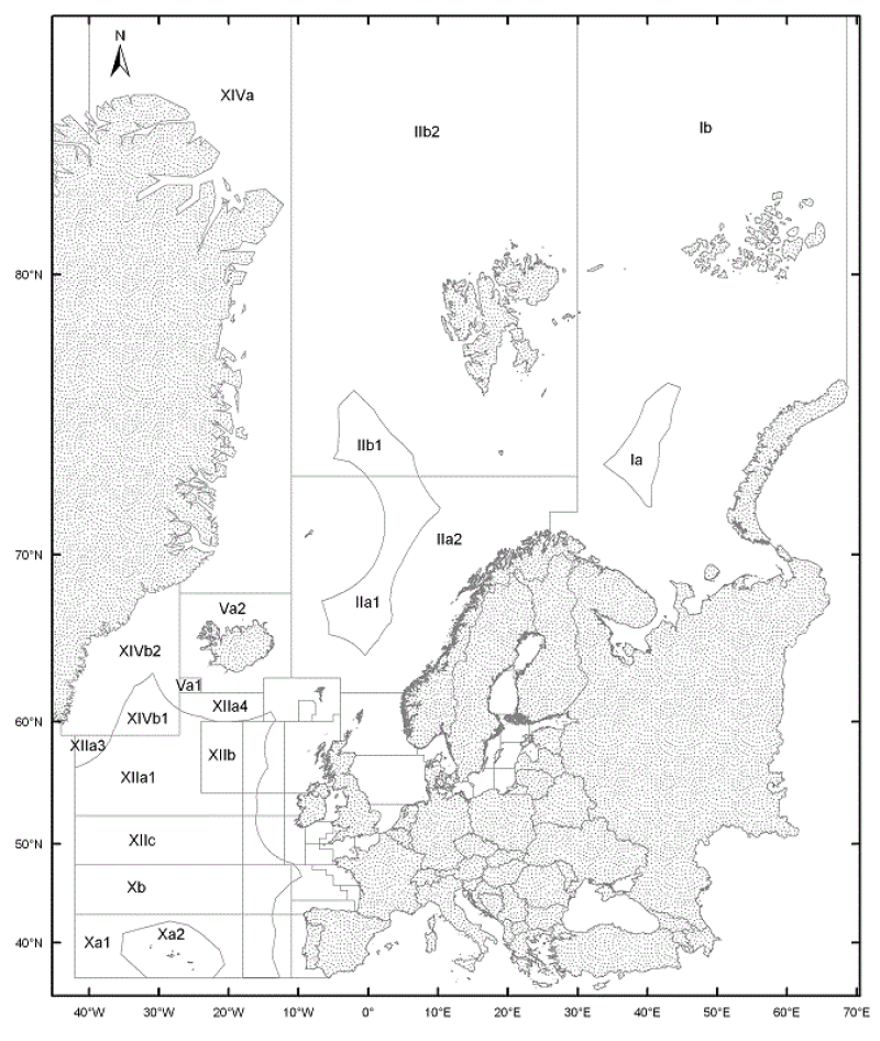
The ICES Statistical Areas delineates the divisions and subdivisions of FAO Major Fishing area 27
-
We took inspiration from a “Matrix of marine activities” (appropriate for each IUCN management category) extracted from IUCN paper, to achieve the first objective by computing 1 product comprising the following 12 components: Product ATLANTIC_CH02_Product_1 / MPA Atlantic network classified in IUCN classification • Traditional fishing area • Sustainable fishing area (industrial) • Leisure fishing area • Leisure activity area (diving, surfing, tourist beaches) • Shipping area (shipping trajectory, aids navigation) • Scientific activity area • Renewable energy generation facility area (ocean energy facilities, wind farms) • Aquaculture area (finfish production, shellfish production) • Shipping infrastructure area (harbours, dredging area...) • Waste discharge area • Mining area (aggregate extraction, hydrocarbon extraction) • Habitation area (urban area) Each geographic information required for the components was compiled into a layer in grid format. These grids were intersected with the MPAs layer to assign each MPA a IUCN category according to the conditional matrix illustrated below : If the MPA area contains : Habitation area (urban area) The IUCN category is :V If the MPA area contains : Mining area (aggregate extraction, hydrocarbon extraction) The IUCN category is V If the MPA area contains : Waste discharge area The IUCN category is : V If the MPA area contains : Shipping infrastructure area (harbours, dredging area...) The IUCN category is IV If the MPA area contains : Aquaculture area (finfish production, shellfish production) The IUCN category is IV If the MPA area contains : Renewable energy generation facility area (ocean energy facilities, wind farms) The IUCN category is IV If the MPA area contains : Leisure fishing area The IUCN category is IV If the MPA area contains : Sustainable fishing area (industrial) The IUCN category is IV If the MPA area contains : Shipping area (shipping trajectory, aids navigation) The IUCN category is II If the MPA area contains : Leisure activity area (diving, surfing, tourist beaches) The IUCN category is Ib If the MPA area contains : Traditional fishing area The IUCN category is Ib If the MPA area contains : Scientific activity area The IUCN category is Ia
-
It's a study of MPA connectivity with assessment of : -size -shape -spacing between each MPA
-
The aim of the product is to represent areas where all forms of resource extraction are prohibited such as: • fishing • aggregate extraction • hydrocarbon offshore facilities • aids to navigation • habitation The product is specified through the same components as for the first product plus 2 additional ones: • Pipe lines and cables • Military activity
-
We took inspiration from a “Matrix of marine activities” (appropriate for each IUCN management category) extracted from IUCN paper, to achieve the first objective by computing 1 product comprising the following 12 components: Product ATLANTIC_CH02_Product_1 / MPA Atlantic network classified in IUCN classification • Traditional fishing area • Sustainable fishing area (industrial) • Leisure fishing area • Leisure activity area (diving, surfing, tourist beaches) • Shipping area (shipping trajectory, aids navigation) • Scientific activity area • Renewable energy generation facility area (ocean energy facilities, wind farms) • Aquaculture area (finfish production, shellfish production) • Shipping infrastructure area (harbours, dredging area...) • Waste discharge area • Mining area (aggregate extraction, hydrocarbon extraction) • Habitation area (urban area) Each geographic information required for the components was compiled into a layer in grid format. These grids were intersected with the MPAs layer to assign each MPA a IUCN category according to the conditional matrix illustrated below : If the MPA area contains : Habitation area (urban area) The IUCN category is :V If the MPA area contains : Mining area (aggregate extraction, hydrocarbon extraction) The IUCN category is V If the MPA area contains : Waste discharge area The IUCN category is : V If the MPA area contains : Shipping infrastructure area (harbours, dredging area...) The IUCN category is IV If the MPA area contains : Aquaculture area (finfish production, shellfish production) The IUCN category is IV If the MPA area contains : Renewable energy generation facility area (ocean energy facilities, wind farms) The IUCN category is IV If the MPA area contains : Leisure fishing area The IUCN category is IV If the MPA area contains : Sustainable fishing area (industrial) The IUCN category is IV If the MPA area contains : Shipping area (shipping trajectory, aids navigation) The IUCN category is II If the MPA area contains : Leisure activity area (diving, surfing, tourist beaches) The IUCN category is Ib If the MPA area contains : Traditional fishing area The IUCN category is Ib If the MPA area contains : Scientific activity area The IUCN category is Ia
-
It's a study of MPA connectivity with assessment of : -size -shape -spacing between each MPA
-

-